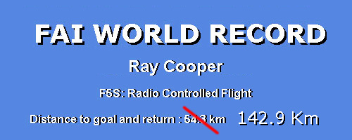
On May 27, 2006, Australian Ray Cooper yet again set a new world distance record for Electric Powered, Fixed Wing Model Aircraft.FAI Ratification: PendingLocation of flight : Yarrawonga - Nathalia, Northern Victoria - Australia Jump to the day in pictures Description of Record Attempt Preparation for this attempt began many months before, a new model was constructed with room to carry more batteries and also setup for the sensors and telemetry link. (Sensors included motor current, voltage both motor and rx/servo, motor temperature and altitude with vario function) The sensor board and telemetry link was the result of work carried out by Monash University's Dept of Elec. & Comp. Sys. Eng. UAV Group. (The Group had supported me for my last two World Records). The information coming from telemetry was invaluable and takes a lot of the guess work out of the flight. Another improvement was to mount the RF module for RC transmitter on the roof of the car and have an umbilical cord leading into the car for the transmitter. This arrangement was much more desirable and making the trip more comfortable, rather than having the RC transmitter antenna poking out through the side window. Also on the roof was the receiver antenna for the telemetry link. The ground station display was mounted on the dash board for convenient viewing. This time a reconnaissance trip was done the weekend prior to the record attempt with the view to find suitable roads. We were looking for back roads with low traffic volume, did not pass through towns, clear of tree obstacles and preferably with bitumen surface. The roads running east-west between Yarrawonga and Nathalia looked promising, although there are many north-south roads that intersect these, which could slow our progress. A bit of research revealed we needed to be south of Yarrawonga to avoid the Yarrawonga airfield and model club. At the other end of the course, the best road departing from Nathalia was about 1 Km north of the town. This meant we had a north-south offset of approx. 4 Km between the two ends and this would add a total of 8 Km to the trip, with no gain in the straight line distance measurement. The roads selected were within our criteria with a mix of gravel, dirt and bitumen. Our furthest distance on the selected course would be approx. 71 Km, as a 1/2Km stretch of trees blocked our passage further east. An alternate route could have been used if we were prepared to travel a further 5 Km south, for a straight line distance gain of about 12 Km. A practice flight took place on the weekend of the reconnaissance. The weather was fine with a southwest wind of 10 to 12 knots gusting to 15 plus. Not ideal conditions, but would test equipment etc. The turning point was set about 42 Km out, with the flight starting from Nathalia heading east. As we had a semi-tail wind, our out-bound speed was good at about 48 Kph. Our return trip was very slow, around 33 Kph, as the now semi-head wind impacted on ground speed. Distance traveled was 88 Km with a total flight time about 2 1/2 hours. Lessons learned: cross wind to the course is better, if there is a head wind component, do your out-bound leg first into wind, this gives you an easier return trip. The weekend weather forecast for the record attempt was looking promising. A large high was positioned across the southeast of Australia and this was creating stable conditions in northern Victoria. The wind forecast was for light southeast to southwest winds, both good directions for the selected course. A phone call to Ray Pike (Directing Official) put the wheels in motion. Ray had been on standby for some time, as well as Greg Egan (Driver and MAAA Observer). We were still short one MAAA Observer, but a phone call to Pat McMahon solved that problem. (Many thanks to Pat for coming out on short notice) Saturday 27/05/2006 dawned with clear blue skies and frost (a chilly start!). We traveled from Oxley to just south of Yarrawonga, picking up Pat on the way through. Our goal was set with the turning point 71.4 Km west at Nathalia. The wind at the launch point was swinging around the compass and with the latest forecast predicting southwesterly winds for early afternoon the east to west run seemed the best option. Time slipped by as we assembled the model, installed the antennas etc. on the roof racks, did range tests and had taken the obligatory photos; it was now about 10:40 am. The model was hand launched by Ray Pike from the road towards the north, full throttle (11 amps) gave a steady climb to approx. 60m at which point I throttled back to cruising current of about 2 amps and trimmed the model out. I did a few circles while we all got in the car and buckled up and then it was off down the road. It was obvious that the conditions were different to the previous weekend; I was already setting a slightly higher cruising current to maintain level flight and the air seemed dead. Our average ground speed was around 46 Kph, not as fast as I had hoped given there was next to no wind. The model's average height AGL on the out bound leg was 80 m. Flying into sink required more motor throttle to climb out (2.8 amps approx.). In lift the throttle was reduced, to conserve energy. As we progressed our ground speed slowly decayed (41 Kph) and we believed there was more wind at the altitude the model was flying at. (There was no evidence of much wind at ground level) During the trip Ray and Pat were busy using the GSP navigation (laptop on back seat with mapping software) to ensure we remained on track and they were also imputing telemetry data into the spread sheet. As we approached the turning point (about 12.30 pm) the trees were beginning to move in the wind, the southwest wind was stating to push through. We rounded the turn point and stopped the car. The crew got out and stretched their legs, took more photos, while I circled the model over head. This stop was about 3 1/2 minutes. As soon as we moved off again, it was obvious the return trip would be faster, our ground speed was already up to 55 Kph, the tail wind component was pushing the model along nicely. Lift was also on the improve, the average height AGL on the return leg was now 107 m. Not much of a difference, but it did make throttle management easier, although having said that, the model was not tracking as well as before and I seemed to fighting the direction control, there was increased turbulence with the wind and thermal activity. With the increased altitude and tail wind it was becoming harder to keep up with the model at some of the road intersection; especially those with give way or stop signs. The model would disappear into the distance pretty quickly. A quiet word to �Greg rally-cross Egan� had us zooming down the dirt roads (complete with ruts and pot holes!) in hot pursuit and speeds in excess of 80 Kph. This certainly made the home leg go faster. Before long we had returned to the launching point. It was time to land; a few more circles overhead and a practice landing approach gave the �paparazzi� time to focus. Apart from avoiding trees, this was uneventful (flaps help in tight situations) with the model coming to rest about 50 m from the launch point, 3 hrs and 20 minutes after launching. These events don't happen without the support and help of others, who give up their time to be involved. Again a big thank you to Ray Pike who has been with me for 3 world record attempts, his enthusiasm just keeps on going! Thanks to Greg Egan for his excellent driving skills and Pat McMahon for data entry and video filming. Also thanks to the UAV Group at Monash University for support and use of the sensor and telemetry link. And finally, a special thank you to my wife, Anne, and daughters, Emma & Beth, for supporting me through another record attempt. Some Statistics:
A Sensor board on the aircraft uses a PIC microcontroller for measuring; current (hall effect), volts, motor temperature, altitude (pressure sensor). It also counts the number of receiver fail safe glitches. This information is then sent to the ground station using a Radiometrix 151.3Mhz 10mW transmitter (mounted in the tail of the aircraft). The ground station has a matching Radiometrix receiver with another PIC microcontroller which decodes the information and displays it on a 2 line LCD. Model Specifications:
The Day in Pictures Ray Cooper preparing the model IMG_260.JPG by Ray Pike Save A4 size to desktop
 The Model IMG_261.JPG by Ray Pike : Save A4 size to desktop
 FAI Rep. Ray Pike documenting the assembly of the model IMGP3937.JPG by Greg Egan : Save A4 size to desktop
 FAI Rep. Ray Pike documenting the assembly of the model IMGP3939.JPG by Greg Egan : Save A4 size to desktop
 Remote transmitter RF module and telemetry mounted on roof rack IMGP3944.JPG by Greg Egan : Save A4 size to desktop
 FAI Rep. Ray Pike makes a final pre flight check IMGP3945.JPG by Greg Egan : Save A4 size to desktop
 FAI Rep. Ray Pike launch run IMG_266.JPG by Greg Egan : Save A4 size to desktop
 We're off ! IMG_268_A.JPG by Greg Egan : Save A4 size to desktop
 We're off ! (detail) IMG_268_B.JPG by Greg Egan : Save A4 size to desktop
 En Route IMG_285.JPG by Ray Pike : Save A4 size to desktop
 Overview of course MAP-1.jpg : Save A4 size to desktop
 At turning point, circling over head IMG_294.JPG by Ray Pike : Save A4 size to desktop
 Turning point MAP-2.jpg : Save A4 size to desktop
 Departure point MAP-3.jpg : Save A4 size to desktop
 We did it. Ray Cooper 'one happy camper' IMG_298.JPG by Ray Pike : Save A4 size to desktop
 GPS trip computer IMG_301.JPG by Ray Pike : Save A4 size to desktop
 Model interior detail after flight IMG_303.JPG by Ray Pike : Save A4 size to desktop
 Group at end of flight, left to right: Pat McMahon, Ray Pike, Ray Cooper and Prof. Greg Egan IMG_303.JPG by Ray Pike : Save A4 size to desktop
|
© Copyright 1999-2006 CTIE - All Rights Reserved - Caution |