
|
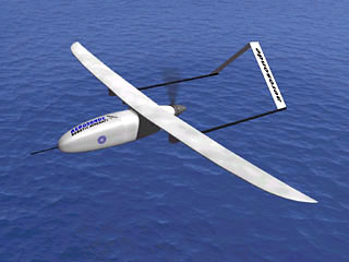 AEROSONDE "LAIMA" CONQUERS THE NORTH ATLANTIC
In August 1998 Aerosonde "Laima" flew into the record books by making the first crossing of the North Atlantic by a robotic aircraft and becoming the smallest aircraft to make the crossing.
The basic characteristics are described in Table 1
Autonomous flight was commanded soon after takeoff. After system checkout, the Aerosonde was sent on its way at 09:59 UTC August 20 1998. Because of the limitations of UHF communications, "Laima" proceeded to completely robotic mode at 10:37 UTC.
_map.jpg) Figure 1 : Flight track of Aerosonde "Laima" The first robotic aircraft to cross the North Atlantic.
"Laima" contacted the landing crew at Benbecula at 12:15 UTC, and was brought in to land under manual control at 12:44 UTC. The landing was within 15 minutes of schedule after a flight of 3270 km in a time of 26 h 45 min. The overall statistics for the flight are listed in Table 2.
*Approximate only: Potential variation 3.7-4.3 kg fuel used, 540-610 km/litre
_pressure.gif) Figure 2 : Surface isobaric and frontal analysis
Surface isobaric and frontal analysis from the UK Meteorological Office for 00 UTC on August 21 with the flight track of "Laima" superimposed. The Aerosonde symbol indicates its location at the analysis time.
_meteostat.gif) Figure 3 : Infrared satellite imagery
Infrared satellite imagery provided by CIMSS at the University of Wisconsin for 13:30 UTC on August 20 and 01:30 and 13:00 UTC on August 21. Aerosonde symbols indicate the aircraft position at these times and the centre panel has the entire flight track for reference. "Laima" stored information on GPS location and altitude, and winds for the entire flight. Unfortunately, temperature and humidity observations were not taken. The time-variation of altitude along the track in Fig. 4 indicates that "Laima" closely followed its specified flight plan.
_altitude.gif) Figure 4 : Altitude variations
Aerosonde-logged GPS altitude variations - the blue curve during the flight with the prescribed altitude shown by the black curve. The aircraft actually tracked along a more accurate pressure altitude. Enroute winds Fig. 5 were always a tailwind and varied from south westerly early in the flight to to northwesterly off Scotland. The maximum winds encountered were over 20 ms-1 (40 kt or 70 km/h) and the wind speed changes associated with passage through the weak frontal zones can be seen near 10 and 20 hours into the flight. Winds predicted by the flight simulation within the NCEP Aviation Model analysis and forecast field conducted at the final update time are indicated by the heavy lines. These were obtained by linear time interpolation between NCEP analyses at 00 and 12 UTC on August 20 and the 00 UTC analysis and 12 UTC forecast on August 21. The remarkably good agreement between the NCEP winds and those experienced during the flight resulted in the accurate estimation of "Laima"'s arrival time at Benbecula.
_wind.gif) Figure 5 : Wind direction and speed
Wind direction blue and speed red measured by "Laima" during the flight. Also shown by the heavy lines are the winds predicted by the flight simulation using the NCEP Aviation Model. "Laima" was one of four aircraft launched from Bell Island during the week of 17 August. "Piper" was lost to what turned out to be a fairly obvious software problem in the transition from manual to automatic control, while "Trumper" and "Millionaire" were lost over the North Atlantic. Since we had no enroute communication we do not know why "Trumper" and "Millionaire" failed to arrive, but the fault is presumed to lie with one or another of several low-reliability parts in the current design. These are being redesigned as the development program proceeds. The North Atlantic crossing by "Laima" capped a good year for the Aerosonde project. We have just completed a 3-year development program that has provided the Phase I aircraft that completed the transatlantic crossing. Further developments will lead us to a more robust and flexible aircraft for routine operations, with the first aircraft going into operations in 1999. In preparation for this, we have undertaken 360 h of operations in field exercises off the Australian West Coast (Operational trial for the Bureau of Meteorology), from Vancouver Island (for the Canadian AES), and from Dongsha Island with scientists from Taiwan for the South China Sea Monsoon Experiment. Some general milestones that have been achieved are provided in Table 3. There is a lot left to do, but there is no longer any doubt that the concept works.
The Atlantic demonstration was possible only because of the efforts of many people and organisations. We would like in particular to thank the staff of Transport Canada, Nav. Canada, the UK Meteorological Office, and the UK Civil Aviation Authority. We are also very grateful indeed to our very gracious and enthusiastic hosts on Bell Island and at the Benbecula Range. The celebration is tempered with sadness. Sir James Lighthill was a great friend of the project during a difficult early period. He died in July whilst attempting his fifth swim around Sark Island in the English Channel. James would have been delighted to see this success. The Aerosonde project has received its major funding by an Australian Tax-Syndication Program at Environmental Systems and Services (ES&S), together with grants from the US Office of Naval Research and Department of Energy, and the Australian Bureau of Meteorology. The major sponsors for the North Atlantic Flight were the US Office of Naval Research and ES&S, with additional support provided by the University of Washington, The Insitu Group, the Boeing Co. and L-3 Communications, Conic Division. As a footnote, "Laima" now hangs proudly in the Seattle Museum of Flight, Washington, USA
|
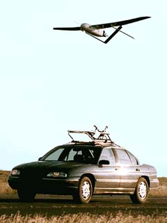 "Laima"'s flight commenced at Bell Island Airport using manual control and launch from a car roof rack.
Return to Aerobotics Home
© Copyright 2000 CTIE - All Rights Reserved - Caution |